How do you know you have reached North or South Pole without GPS?
Having read about the recent foot traverse of Antarctica by Colin O'Brady I was wondering which means the polar explorers of former, pre-GPS times used to determine that they had reached the North or South Pole. Obviously, you cannot use a compass since it would guide you to magnetic north or south and not to the pole itself.
So what means did they use or (to make it a bit more open) could they have used?
This post was sourced from https://outdoors.stackexchange.com/q/21454. It is licensed under CC BY-SA 4.0.
3 answers
Amundsen's team used a meter on their sledges to get close (dead reckoning) and then sextants to confirm the position.
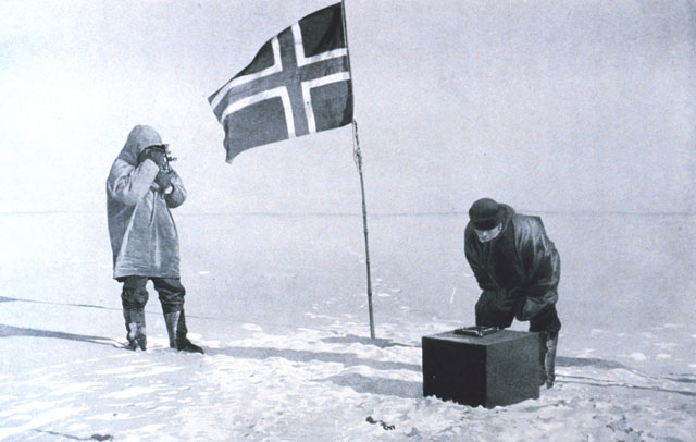
Using Amundsen's diary, Roland Huntford (in The Amundsen Photographs) describes the photo as "Shooting the sun at the South Geographical Pole. Amundsen (left) is holding a sextant. Helmer Hanssen (right) is bending over the artificial horizon, which is a tray of mercury. Amundsen is lining up the direct image of the sun with its reflection in the surface of the mercury."
Amundsen's original South Pole Station
When their sledge meters indicated they should be at the right place, they stopped at the location marked "Sledge" on the map at right (from The South Pole) to determine their position more accurately from sun shots. Amundsen then sent three men out on sledges at 90° intervals. Each went about 10 statute miles; in this way he assured that his party had encircled the Pole.
...
At Polheim the team took a series of hourly observations for a 24-hour period to confirm their location
Amundsen's original South Pole Station
For the next three days the men worked to fix the exact position of the pole; after the conflicting and disputed claims of Cook and Peary in the north, Amundsen wanted to leave unmistakable markers for Scott.[139] After taking several sextant readings at different times of day, Bjaaland, Wisting and Hassel skied out in different directions to "box" the pole; Amundsen reasoned that between them they would bracket the exact point.[140] Finally the party pitched a tent, which they called Polheim, as near as possible to the actual pole as they could calculate by their observations. In the tent Amundsen left equipment for Scott, and a letter addressed to King Haakon which he requested Scott to deliver
People still use sextants today, and they are still the best way to find latitude/longitude without GPS so it seems like is what one would use.
0 comment threads
I'll expand a bit on how one would use a sextant to locate the north or south pole.
The basic arrangement needs a horizontal reflective plane, for which Amundsen used a pool of mercury. A precisely weighted mirror could work also, but a pool of mercury is more robust and doesn't go out of calibration. Sextant measures the angular distance between two visible objects, in this case between the sun and its reflection in the horizontal surface.
This angle is twice the elevation of sun above the horizon. If you are standing at exactly the north (or south) pole, sun will remain at the same elevation all through the day. There will be a small linear change due to earth's orbit around the sun, but no cyclic 24-hour change because you are on the earths rotational axis.
Now, you can take multiple measurements over the day and draw a graph. Even though sun remains at the same elevation, it will still move in a circle around you, so each measurement corresponds to a different direction.
If the elevation graph is flat, you have found the pole. If it however resembles a sine wave, you can use the information to move closer to the pole. The direction where the sun's elevation is lowest is towards the pole, and the distance to the true pole can be calculated from the difference between lowest and highest elevation.
This post was sourced from https://outdoors.stackexchange.com/a/21457. It is licensed under CC BY-SA 4.0.
0 comment threads
Take a time-lapse photo of the sky directly overhead at night. The moving stars will form circles in your photo, and if the center of the circles is directly overhead, you are there.
This post was sourced from https://outdoors.stackexchange.com/a/21456. It is licensed under CC BY-SA 4.0.
0 comment threads

0 comment threads