Hiking in SE France
What are:
a)some good resources for 1-2 day hikes in southern France, between Lyon and Nice?
b)some good 1-2 day hikes between Lyon and Nice?
I am looking for something with scenery (e.g. lakes, mountain pass, above tree line).
I have found the area around the town of Gap (Southeast of Grenoble) in the Parc National des Ecrins appears very nice. Can anyone suggest a particular entry point and hike, as well as logistics (best place to park a car overnight or arrive by bus/train? best places to sleep - any huts or villages)?
I'm using this site to figure out some of the hikes: Sentiers en France (Sentiers proches de Gap).
I am open to considering other options nearby that may be more accessible from Nice and Lyon (different people are coming from different parts); Corsica is a little far given the time frame we have.
Thank you.
This post was sourced from https://outdoors.stackexchange.com/q/10664. It is licensed under CC BY-SA 3.0.
1 answer
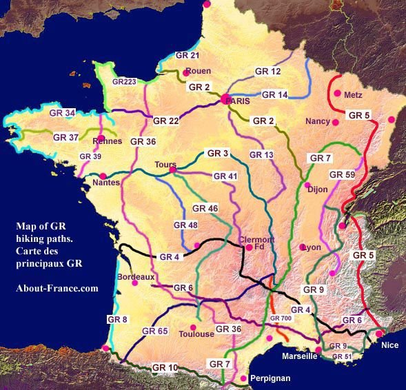
I agree that the sources on the internet for the GRs (grandes randonnées, the main long-distance trails in France) are a bit old-fashioned, and not ideal for finding routes. However here are some pointers to get you started -- I've linked to pages that might help you but the parent websites are worth a browse. In general French websites assume some familiarity with a map of France -- regions are often shown out of context -- as well as the names of the various organisational areas. france-randos.com has search facilities and the ability to browse by region and département (I started with Alpes-de-Hautes-Provence; Alpes-Maritime is another good option). In the resulting list I found the GR4. Descriptions of the GRs can be found at gr-infos.com, here I've linked to a section of the GR4. This map (link rather than inline image as no rights information given) has a nice overview of the GR network, suggesting that the GR5 might be worth a look for you.
Sources on the regional GRP (grandes randonnées de pays) routes are almost by definition regional, and again hard to find online. Some regions have paper guides available.
French Hiking maps of any decent scale tend to cover a fairly small area, but the 1:100 000 maps are fine for the GRs which are all waymarked on the ground as well as shown on the maps. I suggest getting hold of a few maps once you've narrowed down you search a little.
If you're prepared to take a ferry from Nice, the GR20 (I mentioned in my comment) in Corsica has some excellent hiking and scenery, and you're up in the mountains within a few km of the port (as I remember from 20 years ago!). Corsica is very different from mainland France (culture and geology) and well worth a visit.
This post was sourced from https://outdoors.stackexchange.com/a/10666. It is licensed under CC BY-SA 3.0.
0 comment threads

0 comment threads